


What a potentially record-strength Pacific warming event means for storms, harvest, ski season and energy demand across every region of the country.
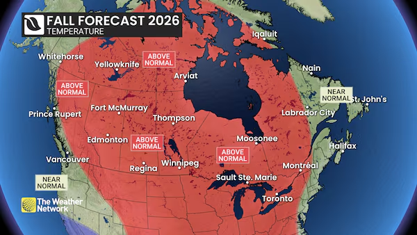
A national three-month outlook released this week points to an El Niño fall forecast that keeps much of Canada milder and, in many regions, drier than normal through September, October and November, with the reliable arrival of winter pushed further down the calendar. The outlook, published by The Weather Network and reported on September 9, 2026, attributes the shift to a Pacific warming event that several forecasters believe could rank among the strongest ever recorded.
Senior meteorologist Doug Gillham summarised the season in a single line: “Winter is probably going to wait on the sidelines for a while.” That does not mean a uniformly quiet autumn. September and October are still expected to swing between warm stretches and bursts of chilly, stormy weather, with the balance tipping progressively milder as the season deepens.
Why the El Niño Fall Forecast Tilts Canada Milder
El Niño describes a periodic shift in patches of warm water across the Pacific Ocean that reorganises weather patterns worldwide. In a Canadian autumn, Gillham said, its typical fingerprint is threefold: the storm track slides south of the border, milder Pacific air floods across the country, and cold Arctic air loses its ability to plunge far south.
The combined result is fewer classic fall storms, a softer start to winter, and a quieter Atlantic hurricane season. But the strength of this particular event introduces a caveat that forecasters are careful to flag — an unprecedented El Niño can behave in ways historical analogues do not predict, adding genuine uncertainty to a seasonal outlook.
“Fewer Storms Doesn’t Mean That the Storms That Occur Won’t Pack a Punch”
Gillham’s central warning is about complacency. A quieter pattern on a seasonal map says nothing about the intensity of individual systems that do form.

“Don’t be lulled into a sense of, ‘Oh, we’re just going to have a dry fall and we don’t have to worry about any storms,’” he said. Recent Ontario thunderstorms were cited as an example of the high-impact weather the season can still deliver even when the overall count of storms runs below normal.
For households, municipalities and businesses, the practical translation is that seasonal outlooks guide planning, not preparedness. Emergency kits, drainage checks and continuity plans remain as relevant in a mild autumn as in a stormy one.
British Columbia: A Dry Stretch That Offers Little Comfort to the Fire-Weary Interior
British Columbia’s break from summer heat arrived earlier this year than in recent seasons, but the outlook calls for warmer and drier conditions to dominate the remainder of September and into October. That is unwelcome news for interior communities worn down by repeated wildfire seasons.
“The rest of September into the beginning of October is not good news in that we need more rain than we’ve seen,” Gillham said. Coastal precipitation is expected to edge back toward normal as the season progresses. Winter’s start is forecast to be delayed provincewide, though alpine terrain may still run cold enough for a reasonable opening to ski season.

Prairie Harvest Gets Breathing Room as Winter Holds Off
Across Alberta, Saskatchewan and Manitoba, the theme repeats: mild temperatures dominating, punctuated at intervals by shots of cold air. Most of the Prairies are expected to land on the drier side of normal, with southern Saskatchewan and southern Manitoba closer to typical precipitation levels.
Stormy weather has already slowed the start of harvest in some areas. The offsetting factor, Gillham noted, is time. “The good news is that our backs aren’t up against the wall with the impending arrival of consistent winter weather,” he said, contrasting this year with seasons in which September wintry weather arrived and simply took over.
Ontario and Quebec: A Typical Fall, Then a Drier Turn Into November
Central Canada is forecast to see fairly typical autumn conditions through the rest of September and October, with high-impact storms still possible even if the overall tally runs below normal. A drier pattern is expected to settle in later in the fall and hold into November.
That could be a relief for regions such as Ottawa and Niagara following a summer of record rainfall. On winter’s onset, however, Gillham was blunt about Ontario and Quebec: “We do not expect consistent cold or early winter weather as we wrap up the fall season.” He remains more hopeful about the alpine ski outlook in B.C. and Alberta than about Central Canada.

Atlantic Canada’s Quiet Hurricane Season Comes With a Caveat
The subdued hurricane season is expected to continue in Atlantic Canada, but the outlook carries an important qualifier: it only takes one storm. Very warm Atlantic Ocean temperatures mean any system that does track toward the region could hold onto its intensity and moisture rather than weakening as it moves north.
Regionally, the forecast calls for near-normal precipitation and temperatures, alongside a late start to consistently wintry weather — the same delayed-winter signal seen elsewhere in the country.
Northern Canada Warms Fastest as the Baseline Itself Shifts
Northern Canada is also expected to run warmer than normal this fall, with the exception of near-normal temperatures in western parts of Yukon and portions of Baffin Island.
What counts as a “normal” autumn has moved considerably. Average fall temperatures across Canada are now roughly 2.4 degrees warmer than in the mid-20th century, driven by the burning of fossil fuels. The forecast’s own baseline uses the more recent 1991-to-2020 period, meaning a season described as “near normal” is already measured against a warmed reference point.

The longer trajectory is steeper still. Canada is warming at nearly twice the global average and the Arctic at roughly three times that rate. Under current climate policies, a recent federal scientific assessment projects Canada’s average temperatures rising by five degrees, with Nunavut’s winters potentially more than 10 degrees Celsius hotter by the end of the century.
Global Consequences: Flood, Drought and Extreme Heat Risk Into 2027
While the Canadian read is relatively benign, the same event is a global disrupter. Forecasters expect it to push temperatures higher on top of warming already driven by human activity, raising the risk of serious flooding, drought and extreme heat in various regions into 2027.
Gillham framed the contrast directly: there will be catastrophic effects globally, but it is “not all doom and gloom for the fall in Canada.” For Canadian readers, that distinction matters — a comfortable domestic autumn and a disruptive global year are not contradictory outcomes of the same Pacific pattern.
What a Late Winter Could Mean for Energy and Commodity Markets
Seasonal outlooks are not market forecasts, but a delayed onset of consistent cold has recognisable commercial implications. Heating demand typically builds later in a mild autumn, which can influence natural gas draws, utility load planning and retail patterns from apparel to home improvement. Agriculture sees the flip side: a longer window before freeze-up gives Prairie producers more room to finish harvest operations.

Energy-linked sectors are already navigating a volatile stretch. Brand Magazine has tracked how the Canadian dollar has held near 1.3780 while oil prices stay elevated, and how the loonie’s rally paused as tariff risks resurfaced — reminders that commodity-sensitive markets respond to multiple pressures at once, of which weather is only one input.
How Much Weight a Three-Month Outlook Deserves
Seasonal forecasts describe the tilt of the odds over weeks and months. They do not pin down the date of the first snowfall, the track of a single storm, or the severity of any one event. A few points worth holding onto as the season unfolds:
- Trend, not timetable: “Milder than normal” is an average across a three-month window that still contains cold snaps and stormy bursts.
- Regional variation is real: El Niño is the dominant driver, but conditions differ meaningfully between the B.C. interior, the Prairies, Central Canada, the Atlantic and the North.
- Intensity is separate from frequency: a below-normal number of storms says nothing about how strong any individual system will be.
- The baseline has moved: normals drawn from 1991 to 2020 already reflect decades of warming, so “typical” is a shifting target.
- Record-strength events carry extra uncertainty: an unprecedented El Niño has fewer historical parallels for forecasters to lean on.
Frequently Asked Questions
Does a milder fall forecast mean Canada will skip winter?
No. The outlook points to a delayed and softer start to consistent winter weather, not its absence. Cold shots are still expected to interrupt milder stretches.
Which regions are expected to be driest?
Most of the Prairies are forecast on the drier side, with southern Saskatchewan and southern Manitoba nearer normal. British Columbia is expected warm and dry through late September into early October, with coastal precipitation trending back toward normal later in the season.
Is the ski season at risk?
Forecasters expressed cautious optimism for alpine regions in British Columbia and Alberta, where higher elevations may stay cold enough for a decent start. The outlook was notably less optimistic for Ontario and Quebec.
How long could this El Niño’s effects last?
The heightened global risk of flooding, drought and extreme heat is projected to extend into 2027, according to the outlook.
What is the forecast “baseline” based on?
Normals in this outlook are measured against the 1991-to-2020 period, a more recent reference window than mid-20th-century averages.


